
Home > Apps > Maps & Navigation > スーパー地形 - GPS対応地形図アプリ

| App Name | スーパー地形 - GPS対応地形図アプリ |
| Developer | kashmir3d |
| Category | Maps & Navigation |
| Size | 16.7 MB |
| Latest Version | 4.6.17 |
| Available on |
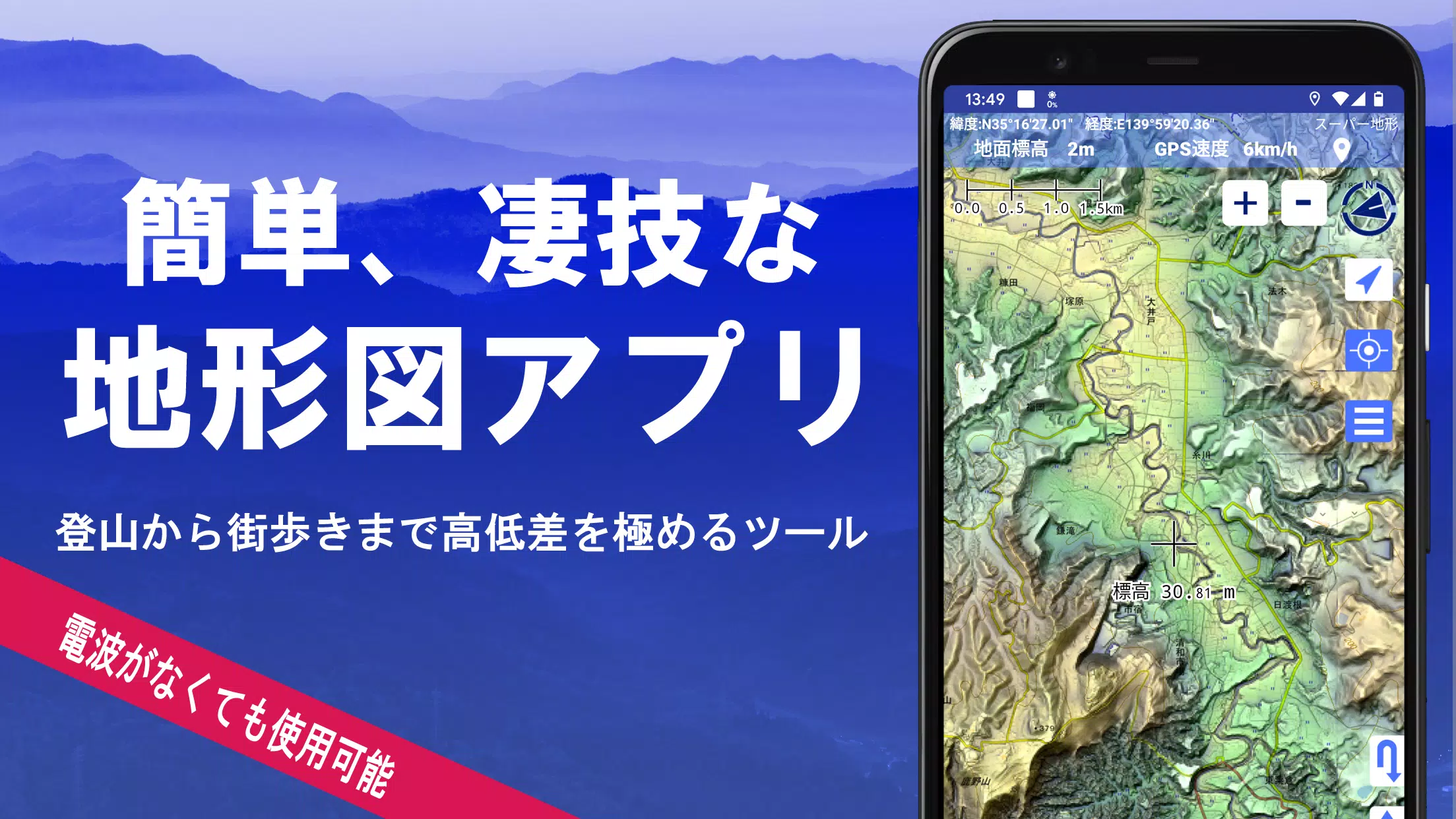
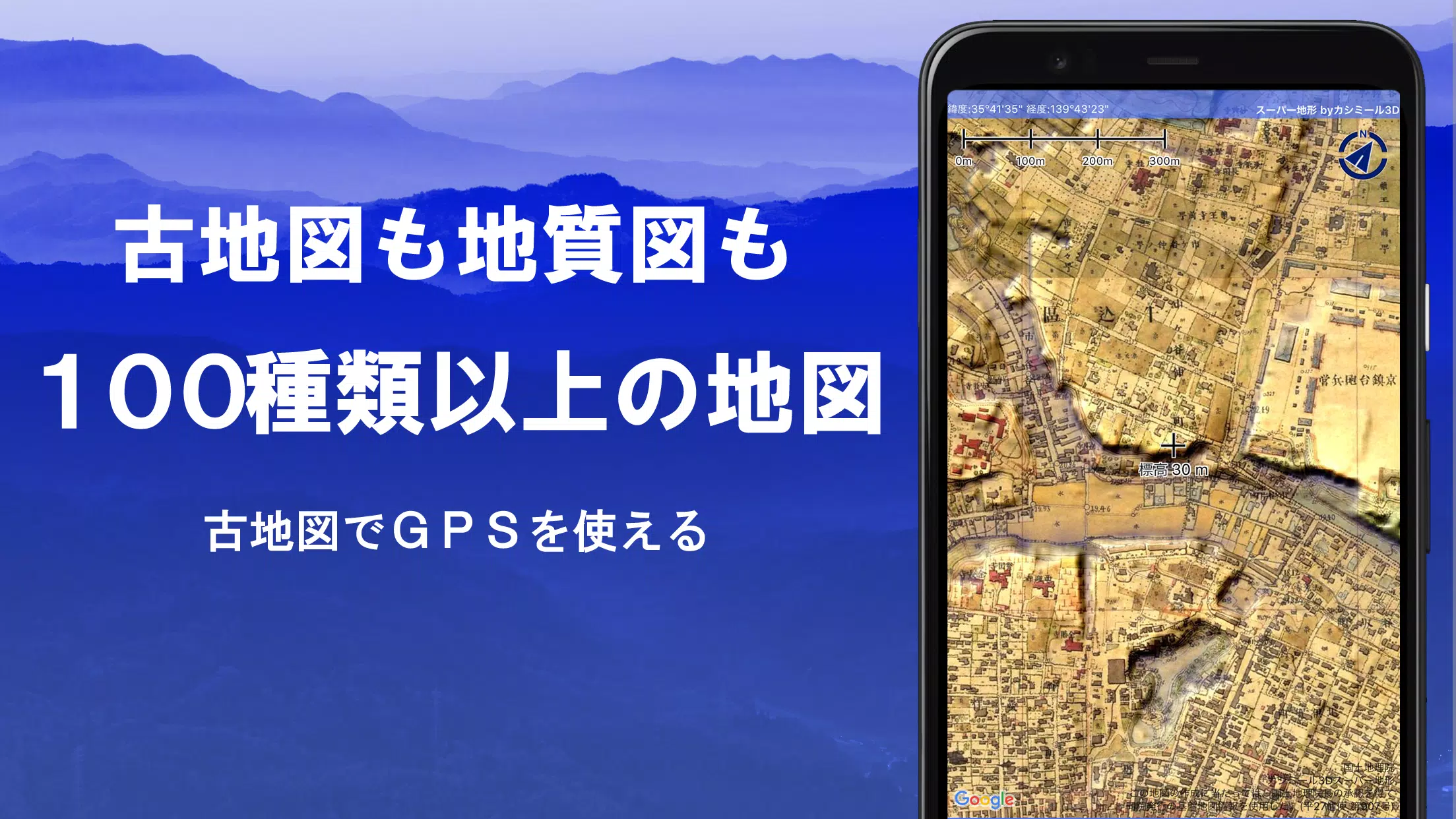


Discover over 100 types of maps at your fingertips, including detailed maps from the Geographical Survey Institute, perfect for everything from mountain climbing to urban exploration. Our app, which received the prestigious 2018 Japan Cartographic Society Award for Best Work, harnesses "super terrain data" to vividly showcase the terrain, enhancing your outdoor adventures.
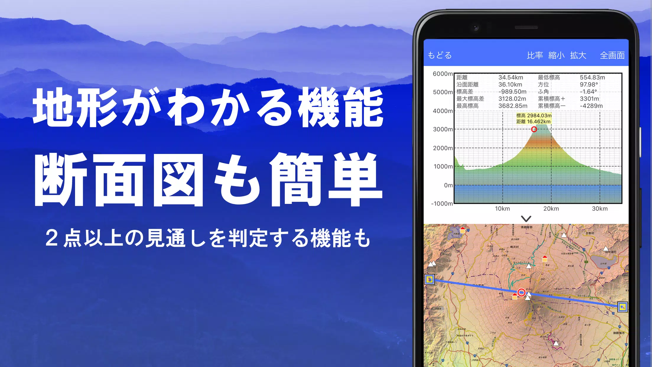
With access to a variety of maps such as topographic, geological, and historical maps, including prewar Ordnance Survey Department maps, you can explore the world with unparalleled detail. Utilize the GPS function to record tracks, edit them with GPX log input/output, and embark on your journeys with enhanced navigation features including audio guidance. Our app also includes a visibility determination function for creating cross-sectional diagrams, useful for observation and radio applications, and can even display buildings where PLATEAU data is available.
Experience the great outdoors with a 360° panoramic view function that aids in mountain identification, and enjoy features like sun, moon, and GPS point display. Whether you're offline on a mountain climb or exploring new cities, our bulk map download and map cache functions ensure you're never lost without a signal. You can also associate photos with specific points, display contour lines from elevation data, and view MGRS grids.
For the tech-savvy explorer, our app supports GeoJSON for reading, displaying, and editing GIS data, shape drawing, and can be used internationally. Print your maps or export them as PDFs, and enjoy the convenience of a dark theme for night use.
A Wealth of Maps at Your Disposal
Our collection includes over 100 types of maps, featuring our proprietary super topographic data and resources from the Geospatial Information Authority of Japan. Note that aerial photographs may vary by age group, with "latest" and "around 1974" offering broader coverage. Enjoy a 5-day free trial of maps using super terrain data after installing the app.
Creating Cross-Sections and Outlooks
Effortlessly generate cross-sections through any point on the map. Our app includes a visibility judgment function that accounts for Earth's curvature and atmospheric conditions, ideal for climbing route checks, wireless visibility assessments, and terrain analysis. Where PLATEAU building data exists, include buildings in your cross-sectional views.
Elevation Palette Function
Customize your map's background with the elevation palette function, allowing you to change colors in 1cm increments to suit your preferences.
Panoramic View
Identify mountains with ease using our panoramic observation map, which integrates with your smartphone's compass for a 360-degree view. Display the sun and moon, including moon phases, to spot phenomena like Diamond Fuji and Pearl Fuji. View GPS points and explore panoramic views of international mountains.
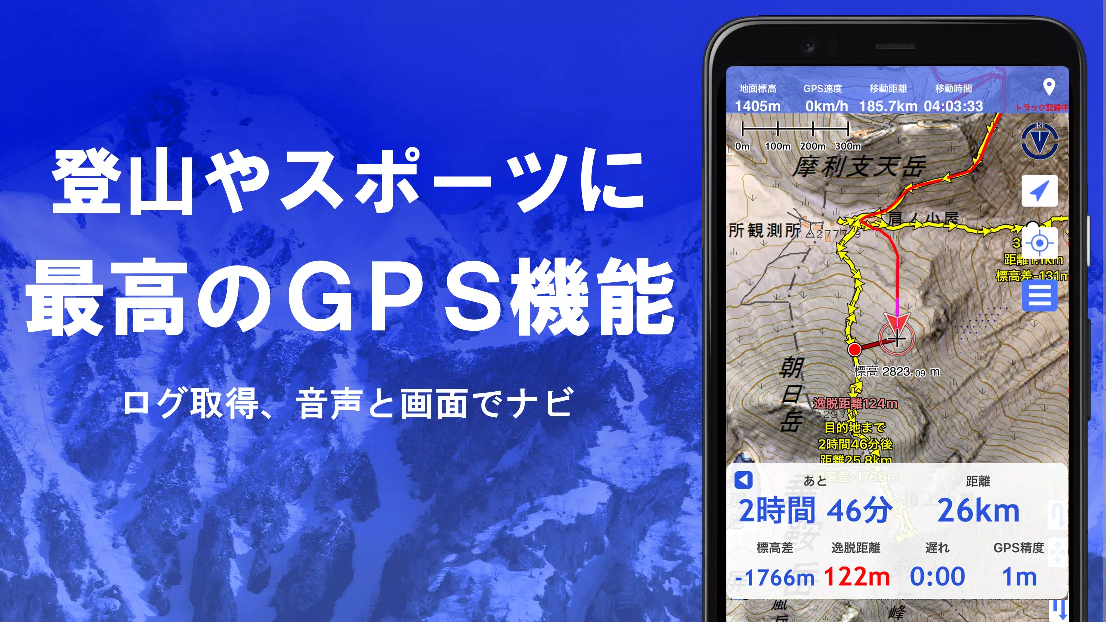
GPS Function
Harness your smartphone's GPS to acquire precise location data and record tracks, perfect for serious outdoor enthusiasts. Visualize recorded tracks with detailed parameters like elevation gain, speed, time, and elapsed time. Receive point alarm notifications via voice and sound as you approach specific points, and seamlessly send map center positions to NaviCon.
GPS Track Summary Playback
Relive your journeys with the GPS track summary playback function, which automatically displays photos taken at specific times along your route. Simply tap the photo icon to view your captured memories.
GPS Navigation Function
Navigate along pre-set tracks with the Track Navi feature, receiving alerts if you deviate from your path to prevent getting lost. Additionally, utilize route navigation for urban exploration and point navigation to reach specific destinations.
GPS Data Editing Function
Manage GPS-related points, routes, and tracks with ease. Organize data in folders, view in a clear tree format, and create tracks directly on the map. Import and export data in GPX format from mountain climbing sites.
Map Usage Outside the Service Area (Offline)
Continue your adventures even in areas without a signal. Our bulk download function allows you to pre-download all necessary scale maps, and the cache function ensures you're always prepared.
Map History Function
Quickly return to previously viewed locations with the map history function, making navigation seamless and efficient.
Custom Map Compatibility
Import and use custom maps created with Kashmir 3D's map cutter, displaying your own maps or scanned images. Ensure images are divided into approximately 256x256 pixels and send the kmz file to Super Terrain via email or Cloud Drive.
GeoJSON Compatibility
Effortlessly display and edit points, linestrings, and polygons from GeoJSON files, and draw new shapes for enhanced data visualization.
Print/PDF Output
Print any map area at a specified scale or create PDFs for professional or personal use.
Cooperation with Other Apps
Seamlessly exchange GPS data in GPX, KML, and GDB formats with other apps and software like Kashmir 3D on your PC, and utilize trajectory data from mountain climbing sites.
Backup Function
Safeguard your data with our comprehensive backup feature, which can be stored and restored from Google Drive, ensuring your adventures are always secure.
About Billing Function
Certain features like super terrain data maps, GPS track functions, and cross-sectional views require in-app purchases. After payment, you'll unlock more search results for place name searches.
- Fees: Annual payment of 780 yen/year.
- Free Trial: Enjoy a 5-day free trial upon installation. After 5 days, some features and maps may be restricted unless a purchase is made.
- Confirmation and Cancellation: Check or cancel automatic updates via Google Play under "Regular Purchase" and select "Super Terrain."
- Price Revision: Prices may change with future enhancements; early purchase is beneficial.
Terms of Use
The copyright holder and developer are not responsible for outcomes from using this app. Upon first use of GPS, you'll be prompted to allow location services. Be aware that continuous GPS use can drain your battery; carry a spare for emergency communication. For detailed navigation function instructions, refer to our PDF guide at https://www.kashmir3d.com/online/superdemapp/superdem_navi.pdf. Note that on some smartphones, track recording may be interrupted due to power-saving features, a common issue across apps.
-
 Trainer's Pokémon Set to Resurface in Pokémon TCG in 2025
-
 Clash of Clans Unveils Town Hall 17: Game-Changing Update Released
-
 Stalker 2: List Of All The Artifacts & How To Get Them
-
 Mastering Parry Techniques in Avowed: A Guide
-
 Shadow of the Depth: Open Beta Now Available on Android
-
 Breaking: Ubisoft Unveils Covert NFT Gaming Venture